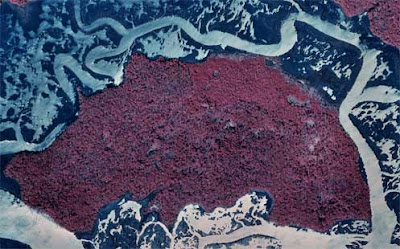
An Infrared aerial photo can loosely be described as "Photography in which an infrared optical system projects an image directly on infrared film, to provide a record of point-to-point variations in temperature of a scene." (answers.com). The photo to the left is an infrared photograph taken of Grover Island, and the colors clearly show that the top of the island/middle of the island (which is only 1.4 miles across...from east to west) seems to have the most activity/heat. The URL for this photo can be found at: http://images.google.com/imgres?imgurl=http://www.camdencountylandtrust.org/grover-aerial-for-web.jpg&imgrefurl=http://www.camdencountylandtrust.org/Grover%2520Island.htm&usg=__88QgpZ_sBXX9t42hp2htXp3Fytc=&h=310&w=497&sz=36&hl=en&start=40&um=1&tbnid=Afu4pMDoA6Z7EM:&tbnh=81&tbnw=130&prev=/images%3Fq%3Dinfrared%2Baerial%2Bphoto%26ndsp%3D18%26hl%3Den%26rls%3Dcom.microsoft:*:IE-SearchBox%26rlz%3D1I7GZFA%26sa%3DN%26start%3D36%26um%3D1
No comments:
Post a Comment