Tuesday
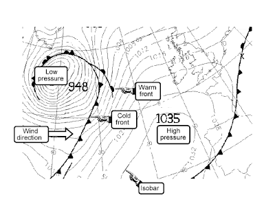
ISOBAR
ISOBAR, essentially, utilizes a line to connect areas with equel atmospheric pressure(s). The map to the left is for a "swell" forecast (for surfuers), and has an emphasis on the Atlantic. The URL for this map is: http://images.google.com/imgres?imgurl=http://www.swell-forecast.com/en/tutorials/info_isobar_e.gif&imgrefurl=http://www.swell-forecast.com/en/tutorials/isob_e.htm&usg=__nWK07OgmB_gWsv5FCAZjWIs1oh8=&h=432&w=576&sz=24&hl=en&start=5&tbnid=mepsPbtKo5zsAM:&tbnh=101&tbnw=134&prev=/images%3Fq%3DISObar%26gbv%3D2%26ndsp%3D18%26hl%3Den
Subscribe to:
Post Comments (Atom)
Followers
Blog Archive
-
▼
2009
(50)
-
▼
April
(49)
- Unclassed Choropleth Maps
- Standardized Choropleth Map
- DOQQ
- DRG
- DLG
- DEM
- Bilateral Graph
- Lorenz curve
- Index Value Plot
- Isopleths
- Isopach
- Isohyets
- Isotachs
- Cartographic Animations
- Isoline Map
- Hypsometric Map
- Cadastral Map
- Star Plot
- Correlation Matrix
- Similarity Matrix
- Stem & Leaf Plot
- Parallel Coordinate Graph
- Box Plot
- Triangular Plot
- Windrose
- Climograph
- Population Profile
- Scatterplot
- Histogram
- Black & White Aerial Photo
- Infrared Aerial Photo
- Bivariate Chloroleth map
- Classed Chloropath Maps
- Range Graded Proportional Circle Map
- Continuously Varibale Proportioanl Circle Map
- ISOBAR
- LIDAR
- Doppler Radar
- Statisical Maps
- Proportional Circle Maps
- Chloropath Maps
- Cartogram
- Flow Map
- DOT Distribution Map
- Propaganda Maps
- PLSS Maps
- Thematic Map
- Topographic map
- Planimetric map
-
▼
April
(49)
No comments:
Post a Comment